


Customized Solutions At Any Scale
SERVICES

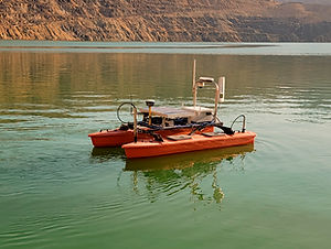
We provide a variety of options to collect sensor data and physical samples through remotely operated surface and aerial vehicles from sites not conducive to conventional methods.

Our team employs a multitude of mapping and imaging methods to help you characterize your sites with diverse topography, terrain, and cover types. We analyze both underwater and over land.
One-off problems are our favorite kind to address. We love nothing more than the chance to use our creative problem solving and extensive field experience to build your custom solution
_edited.jpg)

ABOUT
We are an applied science and technology company in Bozeman, Montana with unique customized solutions for the mining remediation industry. Any situation where remotely sensed, monitored, or operated equipment can be used to keep people out of harms way, we're there.
AppSciTech focuses on research and development in the UAV/USV sector and finds new ways to approach novel problems in hazardous environments. The team has been developing and modifying aerial drones, surface vehicles and marine vessels to take instrumentation to otherwise inaccessible areas around the mountain west region of the US for 8+ years. We are always on the lookout for new and exciting challenges to deliver vital information to our clients.
Check out some examples of our work!
Grab a handout to share with a colleague!
We are a DBA of Fairweather IT LLC


2016
200+
250
Year Established
Aerial Sampling Missions
Km Bathymetric
Survey
10K+
Acres Imaged
PROJECTS


